Submit an Offer Now!
2230 5th Avenue, WAUCHULA, FL 33873
Property Photos

Priced at Only: $1,000,000
For more Information Call:
(352) 279-4408
Address: 2230 5th Avenue, WAUCHULA, FL 33873
Property Location and Similar Properties
- MLS#: O6264081 ( Land )
- Street Address: 2230 5th Avenue
- Viewed: 10
- Price: $1,000,000
- Price sqft: $0
- Waterfront: No
- Year Built: Not Available
- Bldg sqft: 0
- Days On Market: 27
- Acreage: 20.13 acres
- Additional Information
- Geolocation: 27.5163 / -81.8058
- County: HARDEE
- City: WAUCHULA
- Zipcode: 33873
- Provided by: Q BOUTIQUE SPECIALTY REALTY INC
- Contact: Laura Diss
- 407-863-7965

- DMCA Notice
-
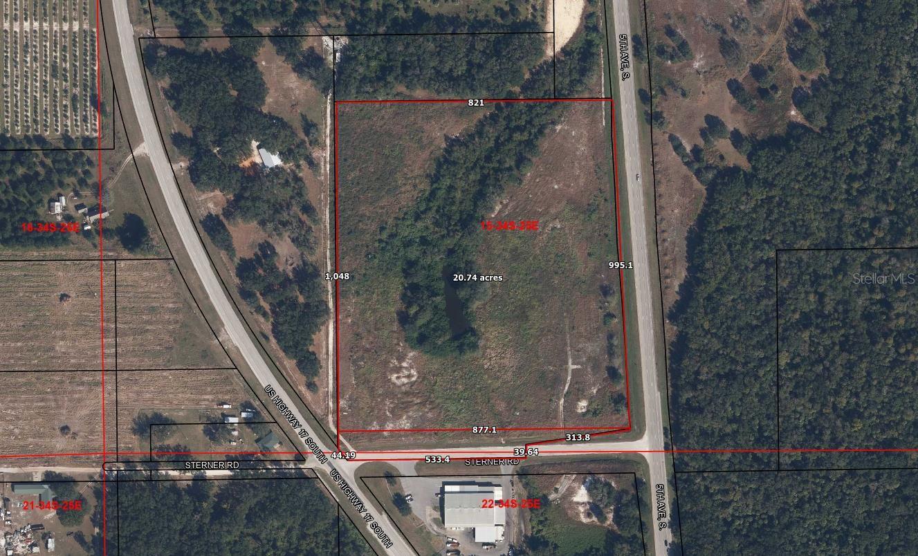
DescriptionThe last prime industrial parcel is available with access to the major transportation corridor in the us. Hwy 17 is zoned for heavy industrial manufacturing and distribution between the gulf coast and central florida! Ideal location for import/export, manufacturing, storage yard, heavy machining, processing raw materials, and agriculture. Easy trucking and import/export access with property line right on us hwy 17s, sterner rd, and 5th ave s on three sides of the parcel. Surrounded by commercial and residential farm zonings, this 20 acre unimproved parcel is zoned for heavy industrial manufacturing, warehousing, storage, fabrication, and governmental and commercial services. There is a utility pole and a small natural pond onsite. The flood zone is x/high and dry. This parcel is in unincorporated hardee county between the city of wauchula and the town of zolfo springs. The i 2 heavy industrial zone is intended for industrial uses that require large storage areas. Hardee co i 2 heavy industrial zone setback requires 50 feet from the front, 20 feet from the rear, and 20 feet from the side of the property lines. The maximum building height permitted is 40 feet. Local trade areas include zolfo springs, fl 33890, bowling green, fl 33834, ona, fl 33865, fort meade, fl 33841, sebring, fl 33872, homeland, fl 33847, sebring, fl 33875, bartow, fl 33830, frostproof, fl 33843. Permitted uses include: grove services, agricultural manufacture of finished products, warehouse, auto salvage, service station, storage yard, sales, machine sales/distribution, storage repair heavy equipment, propane, welding, wholesale distributor, correctional facility, jail, fire station, maintenance facility, storage yard for schools, government, phone and cable operators, septage, agricultural disposal, utility substation, wastewater station/disposal, water plant, lift station, water tower.
Payment Calculator
- Principal & Interest -
- Property Tax $
- Home Insurance $
- HOA Fees $
- Monthly -
Features
Building and Construction
- Covered Spaces: 0.00
- Living Area: 0.00
Land Information
- Lot Features: In County, Rural, Unincorporated
Garage and Parking
- Garage Spaces: 0.00
- Open Parking Spaces: 0.00
Eco-Communities
- Water Source: Well Required
Utilities
- Carport Spaces: 0.00
- Road Frontage Type: County Road, Divided Highway, Highway, Main Throrughfare
- Sewer: Septic Needed
- Utilities: Electrical Nearby, Utility Pole
Finance and Tax Information
- Home Owners Association Fee: 0.00
- Insurance Expense: 0.00
- Net Operating Income: 0.00
- Other Expense: 0.00
- Tax Year: 2024
Other Features
- Country: US
- Current Use: Industrial
- Legal Description: 20.13 AC COM SE CORNER OF SW1/4 RUN S 89 DEG 45M 20S W 940.05 FT TO E R/W LINE SR35 (US17) S 89 DEG 45M 20S W 133.28 FT N 06 DEG 39M 20S W 147.46 FT TO PT ON W R/W LINE OF SR35(US17) FOR POB S 79 DEG 44M 47S W 38.66 FT N 89 DEG 15M 34S W 280.38 FT S 00 DEG 14M 40S E 39.29 FT S 88 DEG 00M 00S W 554.50 FT N 38 DEG 23M 54S W 35.08 FT NW/LY ALONG ARC OF CURVE TO RI GHT 16.03 FT (RADIUS=2810.73 FT, CENTRAL ANGLE=00 DEG 19M 36S, CORD BEARING=N 38 DEG 14M 22S W) N 00 DEG 25M 23S W 995.02 FT N 89 DEG 44M 23S E 835.89 FT TO PT ON SAID W R/W LINE OF SR35(US17) S 01 DEG 23M 18S E 94.34 FT S 04 DEG 35M 38S E 164.04 FT S 03 DEG 20M 02S E 164.07 FT S 05 DEG 58M 07S E 164.10 FT S 05 DEG 10M 01S E 164.05 FT S 03 DEG 54M 24S E 164.05 FT S 06 DEG 39M 20S E
- Area Major: 33873 - Wauchula
- Parcel Number: 1534-25-0000-03890-0000
- View: Park/Greenbelt
- Views: 10
- Zoning Code: I-2
Similar Properties
Nearby Subdivisions


